
שלטו בתפקיד של מפות בטיולים בשבילים בטוחים יותר
Nearly 45% of hiking accidents in some years stem from getting lost, even in an era when GPS devices are ubiquitous. This startling figure reveals a critical gap in modern hiking safety. While technology has transformed outdoor navigation, relying solely on digital tools creates dangerous vulnerabilities. Understanding how to use traditional maps alongside modern devices dramatically improves your confidence and safety on the trail. This guide explores practical map skills that transform uncertain hikers into capable navigators who can handle any situation.
תוכן עניינים
- Why Maps Remain Essential Despite Modern GPS Technology
- Understanding And Using Topographic Maps For Effective Route Planning
- Navigational Techniques: Dead Reckoning And Hybrid Systems
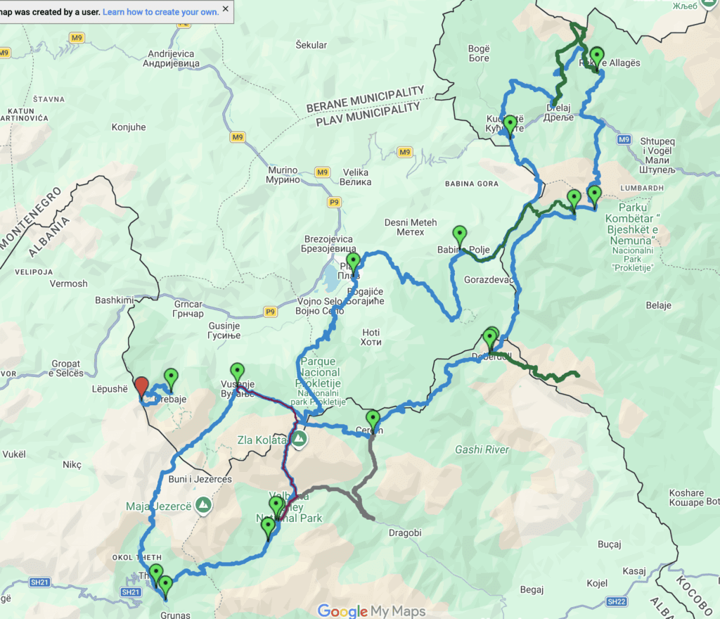
- Planning Safe And Efficient Hiking Routes Using Map Insights
- Explore The Peaks Of The Balkans With Expert Guidance
טייק אווי מפתח
| נקודה | פרטים |
|---|---|
| Maps reduce accident risk | Traditional navigation tools prevent getting lost when GPS fails or provides inaccurate data |
| Topographic maps reveal terrain | Contour lines and elevation markers help assess difficulty and plan safer routes |
| GPS has critical limitations | Signal loss under tree cover and false trail data create dangerous situations |
| Hybrid systems offer reliability | Combining paper maps, compass, and digital tools provides the best navigation security |
| Dead reckoning builds confidence | Calculating position from direction, speed, and time keeps you oriented without technology |
Why maps remain essential despite modern GPS technology
Your smartphone shows five bars and a clear trail on the screen. You follow confidently until the path vanishes into dense brush. The digital map insists you’re on track, but reality tells a different story. This scenario plays out more often than most hikers realize, with inaccurate trail data on digital platforms leading to dangerous situations requiring emergency rescues.
GPS technology faces significant limitations in wilderness environments. Thick forest canopies block satellite signals, creating position errors of hundreds of feet. Canyon walls reflect signals, producing phantom locations that send you in wrong directions. Battery drain in cold weather can leave you without any electronic navigation within hours. These technical failures happen precisely when you need navigation most.
Digital mapping platforms compound these problems with crowdsourced data that includes non-existent trails. Hikers have followed Google Maps routes that led to cliff edges, private property, and impassable terrain. Search and rescue teams increasingly respond to incidents where GPS signals were obstructed by tree cover, leaving hikers with useless devices and no backup plan.
Pro Tip: Always carry a waterproof paper map and compass as insurance, even on familiar trails with good cell coverage.
Traditional navigation tools provide reliable alternatives during technology failures. A paper map works in any weather, requires no batteries, and shows terrain features that help you orient without satellites. Compass bearings remain accurate regardless of signal strength or software bugs. These tools have guided hikers safely for generations and continue to outperform digital devices in challenging conditions.
Experts universally recommend hybrid navigation approaches that combine modern convenience with traditional reliability. Joining group hiking tours with experienced guides demonstrates these techniques in action, building your skills while exploring new terrain safely. The risks of GPS-only navigation include delayed rescues, unnecessary accidents, and potentially fatal outcomes that proper preparation prevents.
Understanding and using topographic maps for effective route planning

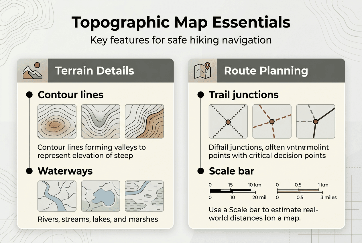
Topographic maps transform abstract terrain into readable information that guides every hiking decision. These specialized tools use contour lines to represent three-dimensional landscapes on flat paper, revealing elevation changes, slope steepness, and terrain features invisible on standard maps. Learning to interpret these elements gives you x-ray vision into the landscape ahead.
Contour lines form the foundation of topographic map reading. Each line connects points of equal elevation, creating patterns that reveal the shape of the land. Lines spaced close together indicate steep slopes requiring extra effort and caution. Widely spaced lines show gentle terrain suitable for faster travel. Index contours appear darker and labeled with elevation values, providing reference points for calculating total climb.
Essential contour line patterns to recognize:
- V-shapes pointing uphill indicate valleys or drainage channels where water flows
- V-shapes pointing downhill reveal ridges that offer better views and easier travel
- Concentric circles show peaks or depressions depending on elevation progression
- Parallel lines running together suggest consistent slopes ideal for steady hiking
- Irregular, chaotic patterns warn of complex terrain requiring careful route selection
Map scales determine the level of detail available for planning. The 1:24,000 scale provides optimal detail for hiking, showing individual trail features, small water sources, and terrain variations. One inch on the map represents 24,000 inches (2,000 feet) on the ground. This scale balances comprehensive coverage with readable detail, fitting typical day hikes on a single sheet.
| Map Element | What It Shows | Navigation Use |
|---|---|---|
| Contour interval | Vertical distance between lines | Calculate total elevation gain |
| Magnetic declination | Difference between true and magnetic north | Adjust compass bearings accurately |
| Scale bar | Distance measurement reference | Estimate hiking time and mileage |
| Legend symbols | Trail types, water, vegetation | Identify route conditions ahead |
| Grid lines | Coordinate reference system | Communicate exact locations |
Terrain symbols add crucial context beyond elevation. Blue lines mark streams and water sources for refilling supplies. Green shading indicates vegetation density that affects travel speed. Brown contours sometimes include hachure marks pointing downslope to clarify terrain direction. Understanding these symbols helps you anticipate obstacles and opportunities along your route.
Magnetic declination creates one of the most common navigation errors. Your compass points to magnetic north, which differs from true north shown on maps by varying amounts depending on location. The declination value appears in the map legend, typically ranging from 0 to 20 degrees. Failing to adjust for this difference causes bearing errors that compound over distance, potentially leading you miles off course.
Pro Tip: Practice reading topographic maps at home using online tools before relying on these skills in the backcountry.
Skillful map reading enables accurate assessment of trail difficulty before you start hiking. Counting contour lines crossed by your planned route reveals total elevation gain. Identifying terrain features like saddles (low points between peaks) helps you find easier passages through mountain ranges. These insights from studying your Peaks of the Balkans hiking guide help you choose routes matching your fitness level and experience, making every hike safer and more enjoyable. Understanding Peaks of the Balkans difficulty through map analysis prepares you mentally and physically for challenges ahead.
Navigational techniques: dead reckoning and hybrid systems
Dead reckoning provides a powerful method for maintaining position awareness when landmarks disappear or technology fails. This technique estimates your current location by calculating direction traveled, speed maintained, and time elapsed from a known starting point. While less precise than GPS, dead reckoning keeps you oriented in fog, darkness, or featureless terrain where other methods become useless.
The basic dead reckoning process involves four steps. First, identify your exact position on the map at a recognizable landmark. Second, determine your bearing using a compass and note the direction of travel. Third, estimate your hiking speed based on terrain and conditions. Fourth, track time carefully and calculate distance covered by multiplying speed by elapsed time. This calculated position becomes your new reference point for continued navigation.
Common dead reckoning challenges and solutions:
- Terrain obstacles force detours that complicate straight-line calculations; compensate by tracking each direction change separately
- Varying speeds on uphills and downhills affect distance estimates; use conservative speed assumptions and verify position frequently
- Compass bearing errors accumulate over long distances; recalibrate at every identifiable landmark you pass
- Fatigue degrades time perception and speed consistency; set regular interval timers to maintain accurate tracking
Hybrid navigation systems combine traditional and digital methods to maximize reliability across diverse conditions. Professional guides have reached 78% adoption of these integrated approaches by 2025, recognizing that each tool compensates for others’ weaknesses. Paper maps provide big-picture context and work without power. Compasses deliver accurate bearings immune to electronic interference. GPS devices offer precise coordinates when satellites are visible. Smartphone apps add real-time tracking and digital convenience.
The synergy between these tools creates navigation confidence that single methods cannot match. You might use GPS to pinpoint your exact location, then transfer that position to your paper map for terrain analysis. Compass bearings confirm the direction shown on your phone app, catching software errors before they lead you astray. This redundancy means no single failure leaves you lost, a critical safety advantage on remote trails like the adventure Balkans trail.
| Navigation Method | Primary Strength | Main Limitation | Best Use Case |
|---|---|---|---|
| Paper maps | No batteries, terrain overview | Requires interpretation skills | Route planning and backup |
| Magnetic compass | Always works, simple operation | Provides only direction | Confirming bearings |
| GPS device | Precise coordinates | Battery dependent, signal loss | Position verification |
| Smartphone apps | Convenient, feature-rich | Fragile, rapid battery drain | Real-time tracking |
Mastering both traditional and modern techniques transforms you from a technology-dependent hiker into a confident navigator. Start by practicing dead reckoning on familiar trails where you can verify accuracy. Gradually increase complexity by navigating in poor visibility or off-trail terrain. Build hybrid system proficiency by using multiple tools simultaneously, learning how each confirms or corrects the others.
Pro Tip: Create a navigation checklist that includes verifying all tools before leaving the trailhead, preventing equipment failures from ruining your hike.
The investment in learning these complementary methods pays immediate dividends in safety and enjoyment. You’ll move faster with confidence in your route choices. Unexpected situations become manageable challenges rather than emergencies. Your hiking experiences expand to include more remote and rewarding destinations that less-prepared adventurers avoid.
Planning safe and efficient hiking routes using map insights
Effective route planning transforms map reading skills into practical hiking advantages. The shortest distance between two points rarely provides the safest or fastest path through wilderness terrain. Efficient planning prioritizes avoiding obstacles and optimizing for both safety and speed, using map features to identify superior alternatives to obvious routes.
Terrain analysis reveals route options invisible to casual map glances. Contour patterns show where ridgelines offer easier travel than valley bottoms choked with vegetation. River bars appear as white spaces between blue water lines, indicating gravel surfaces that allow rapid progress. Areas above treeline, marked by lack of green vegetation shading, provide open walking with expansive views for navigation. These subtle map clues guide you toward paths of least resistance.
Cliff bands present serious hazards that careful map study helps you avoid. Multiple contour lines merging into single thick lines indicate vertical or near-vertical terrain. Route planning around these features adds horizontal distance but eliminates dangerous exposure and slow scrambling. Similarly, dense contour spacing in gullies suggests steep ravines prone to loose rock and difficult footing. Choosing routes that contour around rather than descend directly into these features improves both safety and efficiency.
Strategic route planning considerations:
- Morning sun exposure affects snow conditions; east-facing slopes soften earlier, improving traction
- Prevailing wind direction influences comfort; leeward slopes provide shelter during storms
- Water source locations determine rest stop positions and carrying requirements
- Escape route options offer bailout alternatives if weather deteriorates or injuries occur
- Scenic viewpoints identified from map elevations add rewarding destinations to functional routes
Dynamic route adjustment separates competent navigators from rigid planners. Your pre-hike map analysis provides a framework, not an inflexible mandate. Constantly compare map predictions with observed conditions, updating plans when reality diverges from expectations. That meadow shown as open terrain might be flooded, requiring a higher detour. The ridge that looked intimidating on the map could offer surprisingly easy travel. Flexibility based on real-time observations optimizes your actual hiking experience.
Pro Tip: Mark multiple route options on your map before starting, giving yourself pre-planned alternatives when conditions change.
Time estimation improves dramatically with map-based planning. Calculate elevation gain from contour lines and apply standard hiking paces: roughly 2 miles per hour on flat terrain, reduced by 30 minutes for every 1,000 feet of climbing. Add time for obstacles like stream crossings, boulder fields, or dense vegetation visible on your map. These calculations prevent the common mistake of underestimating duration, which leads to hiking after dark or missing turnaround times.
Route planning for family-friendly hiking routes requires extra attention to map details. Identify gentle grades suitable for shorter legs and less developed balance. Locate interesting features like waterfalls or rock formations that provide motivation and rest stops. Plan shorter distances with lower elevation gain, using map analysis to find loops that maximize variety within appropriate difficulty levels. This thoughtful preparation ensures everyone enjoys the experience.
Good planning reduces physical and mental fatigue by eliminating navigation uncertainty. You hike with confidence rather than constant doubt about direction. Energy focuses on enjoying surroundings rather than worrying about getting lost. The cumulative effect transforms hiking from a stressful challenge into a rewarding adventure, all through skillful application of map insights.
Explore the Peaks of the Balkans with expert guidance
You’ve learned essential map and navigation skills. Now apply this knowledge on one of Europe’s most spectacular hiking adventures. The Peaks of the Balkans traverse offers stunning mountain scenery, authentic cultural experiences, and well-maintained trails perfect for practicing your newfound navigation confidence.
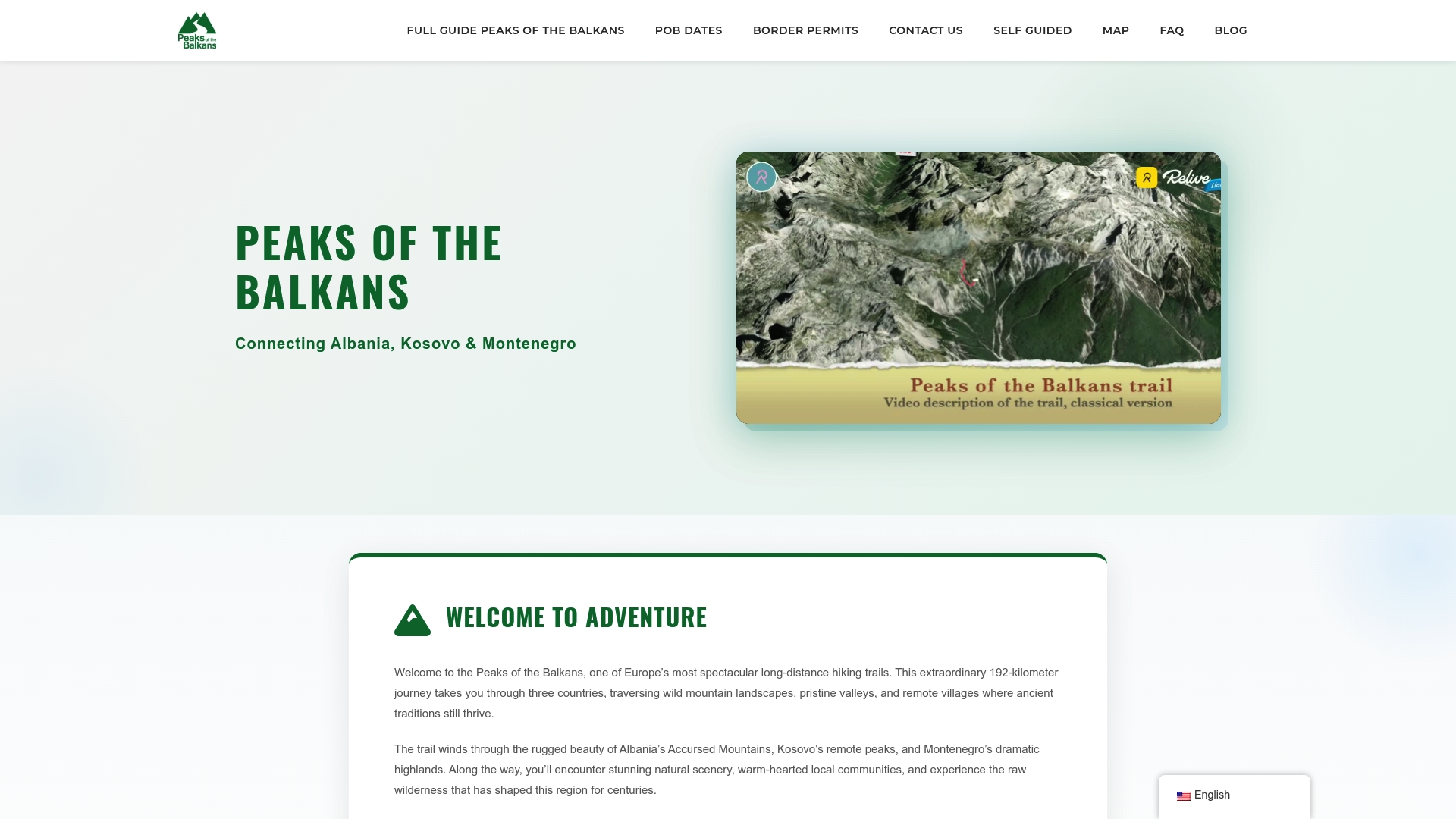
Join our expert-guided טיולי הליכה בפסגות הבלקן where professional guides demonstrate hybrid navigation techniques in real-world conditions. You’ll gain hands-on experience reading topographic maps, using compass bearings, and integrating GPS tools while exploring pristine alpine landscapes. Our comprehensive Peaks of the Balkans hiking guide provides detailed route information tailored for various experience levels, from challenging mountain passes to gentle family-friendly hiking routes suitable for all ages. Every tour combines digital and traditional navigation tools, ensuring secure, memorable experiences that build your skills while creating lasting adventure memories.
שאלות נפוצות
What is the most important map skill for safe hiking?
Reading contour lines and interpreting terrain features ranks as the most crucial map skill for hiking safety. This ability lets you assess route difficulty, identify hazards, and plan appropriate paths before committing to a trail. Map reading proficiency reduces getting lost even when GPS assistance is available. Combining this skill with compass use creates comprehensive navigation confidence that handles any wilderness situation.
How do I adjust my compass for magnetic declination?
Check the declination value printed in your topographic map’s information box before starting your hike. Most adjustable compasses have a declination adjustment screw that you turn to offset the difference between magnetic and true north. If your compass lacks this feature, manually add or subtract the declination from your bearing calculations. Magnetic declination changes over time and failure to adjust causes significant navigation errors, especially over long distances.
Can dead reckoning replace GPS on the trail?
Dead reckoning serves as a valuable backup navigation method but cannot fully replace GPS accuracy. This technique estimates position using direction, speed, and time from a known starting point. It works well for maintaining general orientation when technology fails or in featureless terrain. However, dead reckoning requires careful calculation and experience to avoid cumulative errors. Use it as a complementary tool within a hybrid navigation system rather than a standalone solution.
Why do digital maps sometimes show trails that don’t exist?
Crowdsourced mapping platforms allow users to submit trail data without verification, creating dangerous inaccuracies. Abandoned paths, private property routes, and simple GPS tracking errors get uploaded as legitimate trails. These false trails appear convincing on digital maps but lead hikers into hazardous situations. Always cross-reference digital information with official topographic maps and current trail guides. Trust established sources over user-generated content when planning routes in unfamiliar areas.