Hoe vind je trailheads voor Peaks of the Balkans-wandelingen
How to Find Trailheads on the Peaks of the Balkans (Complete Guide)
Many hikers planning the Pieken van het Balkanpad worry about finding the correct trailhead. In reality, this is rarely the most difficult part of the hike.
Once you are on the trail, navigation is generally straightforward. Most Peaks of the Balkans guesthouses are located directly on or very close to the route, so in many cases you start hiking straight from your accommodation.
👉 The real problem usually happens before you even start hiking—when booking the wrong place to stay.
Belangrijkste afhaalrestaurants
| Punt | Details |
|---|---|
| Offline navigation | Download detailed topographic maps to your phone and cache them so you can navigate without cell service. |
| Paper map backup | Carry a waterproof paper map of the entire Peaks of the Balkans circuit as a reliable backup. |
| Trailhead status checks | Review current trailhead conditions and access road status within 24 hours of your planned start because weather and livestock movements can block routes. |
| Local guidance | Consult local guides and guesthouses to learn which forest roads are passable and where to arrange reliable trailhead transfers. |
Understanding trailheads in the Peaks of the Balkans
A trailhead is the designated starting point of a hiking trail, often with signage or parking facilities. In the Peaks of the Balkans, these starting points vary dramatically from well-maintained access areas near towns to unmarked dirt paths at the edge of mountain villages. Some trailheads feature information boards with route details and safety warnings, while others consist of nothing more than a gap in a fence where locals know the path begins. Knowing your exact starting point matters for three critical reasons. First, accurate navigation depends on beginning from the correct coordinates, especially when trails split or merge with livestock paths. Second, safety protocols require you to inform someone of your planned route, which starts with a precise trailhead location. Third, logistics like transport drop-offs and gear checks happen at trailheads, so confusion here cascades into problems throughout your hike.Unlike other remote hiking regions, the Pieken van de Balkanroute passes directly through villages and seasonal settlements.
- Guesthouses are often on the trail itself
- Trails are marked (red/white/red or white/red/white)
- Locals are familiar with hikers
For example, many stages such as Theth to Valbona of Cerem to Doberdol begin directly from accommodation areas, without the need for complex navigation.
👉 You can explore these in detail in our stages section
The Biggest Mistake: Booking the Wrong Location
This is where most hikers go wrong.
Platforms like Booking.com or Airbnb often show guesthouses that look attractive—but are poorly located for hiking.
This is especially common in:
- Theth (Albania)
- Valbona (Albania)
- Plav (Montenegro)
- Vusanje (Montenegro)
These are large areas, not compact villages.
👉 A cheap guesthouse can easily be:
- 2–5 km away from the trail
- on the wrong side of the valley
- requiring transport early in the morning
This creates unnecessary stress before your hike even begins.
Book Smartly and You Won’t Have Trailhead Problems
If your accommodation is well located, finding the trailhead becomes easy or irrelevant.
The simplest way to ensure this is to book through a local specialist.
👉 We recommend
Natuurlijk avontuur op de Balkan: https://bnadventure.com
They offer self-guided tours of the Pieken van de Balkan that include:
- Carefully selected guesthouses directly on the route
- A navigation app with offline GPS tracks
- Clear directions for each stage
- Local support if needed
This removes the most common problems hikers face in the region.
Main Access Points to the Peaks of the Balkans Trail
Most hikers start from one of these locations:
- Theth (Albania)
- Valbona (Albania)
- Plav (Montenegro)
- Peja (Kosovo)
From these, you can access all main stages of the trail.
👉 On our website, visit the
➡️ [Peaks of the Balkans stages section] (internal link)
to download GPS tracks and see detailed route descriptions.
Important: GPS Tracks Do NOT Start at Your Guesthouse
This is something many hikers misunderstand.
De Toppen van de Balkan GPS-tracks:
- guide you on the trail
- but do not start from your exact location
👉 You will still need to:
- use Google Maps / Maps.me
- navigate to the correct stage starting point
In places like Theth or Valbona, this can take time if your accommodation is not well positioned.
“Check current trailhead conditions and access road status within 24 hours of your planned start time. Mountain weather and local activities can change accessibility rapidly in this region.”
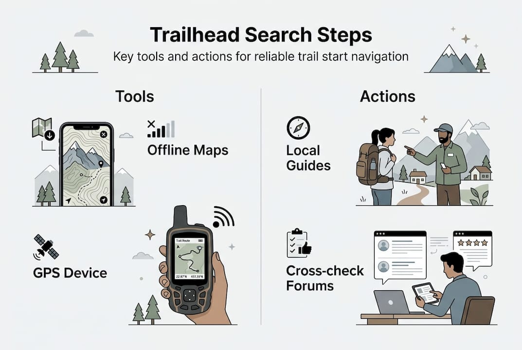
Preparing to find trailheads: tools, resources, and permissions
| Navigation Tool | Strengths | Limitations | Beste gebruiksscenario |
|---|---|---|---|
| Paper Maps | No battery needed, broad overview, reliable | Less detail, can’t show real-time position | Primary backup and route planning |
| GPS Devices | Accurate coordinates, long battery life | Expensive, requires waypoint programming | Technical navigation in poor visibility |
| Smartphone Apps | Detailed trails, photos, offline capability | Battery drains fast, screen hard to see in sun | Day-to-day navigation with power bank |
| Lokale gidsen | Current conditions, cultural context, safety | Cost, availability, language barriers | Complex sections and first-time visitors |
Common mistakes and troubleshooting when finding trailheads
Hikers repeatedly make the same errors when locating Peaks of the Balkans trailheads. The most frequent mistake is assuming cell phone service will be available for last-minute navigation checks. Coverage drops to zero within 15 minutes of leaving most villages, leaving you dependent on whatever maps you downloaded beforehand. Another common problem is trusting a single GPS coordinate without verifying it against landmarks, since some online sources contain coordinates for scenic viewpoints or campsites rather than actual trailheads.| Common Mistake | Why It Happens | Solution |
|---|---|---|
| Relying only on cell service | Underestimating how remote the area is | Download offline maps covering 10km radius |
| Skipping permit research | Assuming trails are open access | Check requirements 2+ weeks ahead, obtain documents |
| Missing trailhead signage | Signs face opposite direction or are weathered | Walk 100 meters in likely direction, look for trail markers |
| Arriving without local currency | Some taxi drivers and permits require cash | Carry small bills in euros for all three countries |
| Starting late in the day | Underestimating travel time to trailhead | Plan to arrive 45+ minutes before intended start time |
“Never begin hiking into unfamiliar mountain terrain without confirmed trailhead coordinates, offline navigation capability, and someone who knows your planned route and expected return time.”Carry hiking accessories for dogs if you’re bringing pets, as some trailheads have livestock guardian dogs that may react to unfamiliar animals. Having proper gear helps you manage interactions safely while respecting local farming practices.