Vuthaj – Zastan – Buni Jezerces – Vuthaj

Vuthaj – Zastan – Buni Jezerces – Vuthaj

One of the most dramatic sections of the Peaks of the Balkans Trail, this long and rewarding hike crosses from Montenegro into Albania through the wild heart of the Accursed Mountains. Surrounded by towering limestone peaks and untouched alpine scenery, it offers an unforgettable high-mountain experience. The journey begins in the village of Vusanje, heading west into the impressive Ropojane Valley. The trail follows a forestry track for approximately 4.5 km through the broad valley floor before reaching a junction where the route branches left toward Buni i Jezerces.

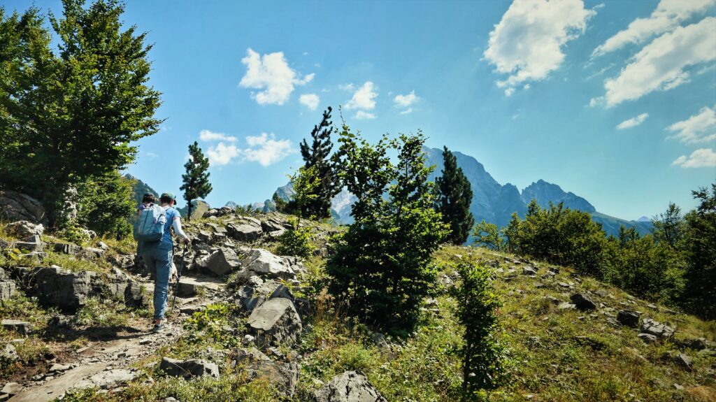
A steady ascent along a 4WD track leads to Katun Zastan (Zastan Karaula), wherethe remains of a former Yugoslav military barracks still stand — silent witnesses to the once heavily guarded Albania–Yugoslavia border. From Zastan Karaula, the marked trail climbs southwest through dense beech forest.
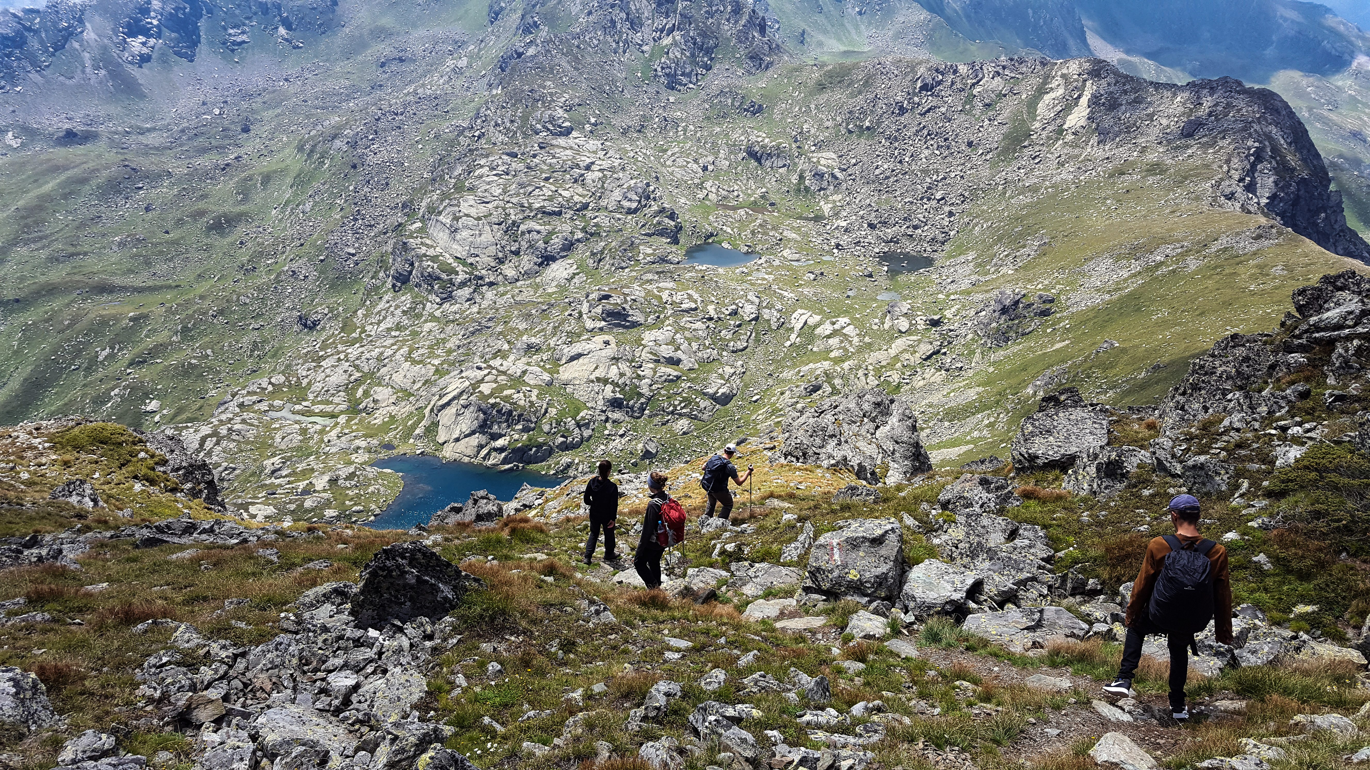
After around 2.2 km, the route emerges above the tree line, just a few hundred meters before the Montenegro–Albania border. Suddenly, the stunning Buni i Jezerces Lakes appear beneath the towering cliffs of the Jezerca massif — a breathtaking alpine panorama. These pristine glacial lakes are fed by underground springs formed from melting snow cascading down the surrounding limestone peaks. During the snowmelt season, up to four lakes may be visible, though some gradually dry out under the summer sun.
This remote alpine basin is a favourite spot for wild camping, offering crystal-clear
waters, star-filled skies, and complete tranquillity in one of the Balkans’ most spectacular mountain settings.

Similar hikes Vusanje – Theth

  • Vuthaj – Zastan – Buni Jezerces – Vuthaj

    Vuthaj – Zastan – Buni Jezerces – Vuthaj One of the most dramatic sections of the Peaks of the Balkans […]

  • Milisevc – Babino Polje

    Crossing from Kosovo to Montenegro This panoramic stage is a carefully designed detour from the classic Peaks of the Balkans […]

  • Grebaje Valley – Taljanka Peak, Montenegro

    The spectacular peaks of Gerbaje Grebaje Valley is accessible by car from Plav, Gusinje or Vusanje. Whether you choose a […]

  • Doberdol – Gjeravice – Gacaferi Pastures

    Doberdol – Gjeravica peak – Doberdol Doberdol – Gjeravica Peak – Doberdol Trail distance: 18 kilometers Accumulative height: uphill: 915 meters Downhill: 915 meters Elevation min: 1534 meters max: 2650 meters Difficulty level: Moderate In this trail you will be…

  • Theth – Nderlyse – Theth

    Theth – Nderlyse – Theth Theth – Nderlyse – Theth Trail distance: 10 kilometers Elevation min: 496 meters max: 784 meters Accumulative height uphill: 266 meters downhill: 435 meters Difficulty level: Easy The village of Theth is one of the…

  • Vusanje (Vuthaj), Montenegro – Theth, Albania

    Vusanje – Montenegro Vusanje (Vuthaj), Montenegro – Theth, Albania Trail distance: 21.35 kilometersElevation min: 726 meters max: 1,748 metersAccumulative height uphill: 1,111 meters downhill: 1,437 metersTime: 8 hoursDifficulty level: ModerateMarkings to the border: red circle/white fills from the border to…

  • Plav, Montenegro –Bor Peak – Vusanje, Montenegro

    Plav – Montenegro Plav, Montenegro –Bor Peak – Vusanje, Montenegro Trail distance: 27.4 kilometersElevation min: 968 meters max: 2,106 metersDifficulty level: ModerateTime: 10 – 11 hoursMarking: red circle/white fill (to be completed before the season begins) This is a long…

  • Babino Polje, Montenegro – Hrid lake Plav, Montenegro

    Babino Polje – Plav Babino Polje, Montenegro – Hrid lake – Plav, Montenegro Trail distance: 20.31 kilometersElevation min: 953 meters max: 2,068 metersCumulative height uphill: 719 meters downhill: 1,250 metersDifficulty level: ModerateTime: 7-8 hoursMarkings: red circle/white fills This is a…

  • Liqenat i Kuqishtes (Guri i Kuq), Kosovo

    Leqinat i KuÇishtёs Leqinat i Kuçishtёs (Guri i Kuq), Kosovo – Babino Polje, Montenegro Trail distance: 15.8 kilometersElevation min: 1,438 meters max: 2,276 metersCumulative height uphill: 1,151 meters downhill: 1,109 metersDifficulty level: ModerateTime: 7-8 hoursMarkings to the border: red/white/red from…

  • Reka e Allages, Kosovo – Pepaj, Kosovo – Drelaj

    Reke e Allages – Hajla peak – Drelaj Reka e Allagёs, Kosovo – Pepaj, Kosovo – Drelaj,Kosovo – Dugaivё, Kosovo – Kuçishtё (Guri i Kuq),Kosovo Trail distance: 23.26 kilometersElevation min: 1,072 meters max: 1,820 metersCumulative height uphill: 1,257 meters downhill:…

en_USEnglish