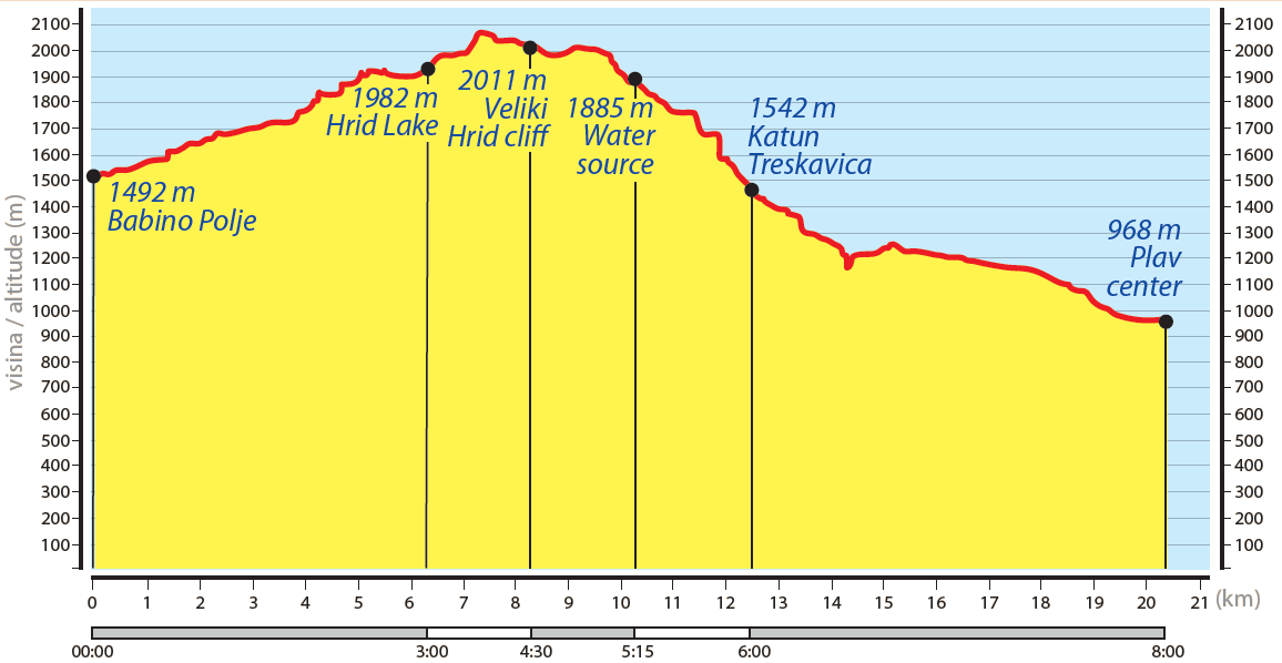
Babino Polje - Plav
Babino Polje, Montenegro – Hrid lake – Plav, Montenegro
Elevation min: 953 meters max: 2,068 meters
Cumulative height uphill: 719 meters downhill: 1,250 meters
Difficulty level: Moderate
Time: 7-8 hours
Markings: red circle/white fills

This is a long transfer hike from Babino Polje to Plav. The hike ascends up from
beautiful Lake Hrid and finishes at the city of Plav.
The best option to separate this day hike into two days is by having an overnight
stay at Treskavički Katun/Katun Treskavica (WP 4g) where the length of the trail
will be 12.1 kilometers on the first day and 8.2 kilometers on the second day.
There are shepherds in summer time at Treskavički Katun (late June to late
September) from whom you can get fresh food and possibly a shelter to stay
overnight. If you separate this hike, the first day would be mostly ascending and
the second day mostly descending to the town of Plav.
Beginning from the path crossing in Babino Polje (300m southeast from the
“Hrid” eco-mountain huts, WP 11f ), and progressing through the woods, the trail
leads to lively Katun Bajrovica where homemade food is available for purchase.
From there, the hiking trail (numbered 542 in the national trail network)
continues west from Tepsijica along the river, Hridska Rijeka, and leads to the
eastern side of the Hrid river (at an altitude of more than 1800m, WP 1g). The lake
can be circled and its western part offers particularly enjoyable views. Lake Hrid
is recognized as a strict nature reserve (the highest level of protection) within
Prokletije National Park and camping is not allowed. Further on, the trail leads to
another viewpoint at Sacirov vrh (Sacirov Peak). Continuing along the ledge of
Veliki Hrid (numbered 540 in the national trail network), the next point is Veliki
Hrid (WP 2g, 2011m). Following down Trskavica hill, past the Katun Treskavica
summer huts (Katun Temnjak, WP 4g), and along the Treskavicka river, there is
a forest road to be crossed in the direction of Kofilajca. The trail leads further
along the northern brim of the Kofiljaca mountain and across the Redzov dol*
to exit the forest at Korita. From there, continuing down a dirt road followed by
an asphalted street (WP 5g), the trail follows along the town’s old, architecturally
characteristic Ottoman symmetry to arrive at the traffic circle in the center of
Plav (WP 6g). In Plav, the Redzepagica kula (tower) and old wooden mosque can
be visited. Stores stocking food, rest stops, and overnight possibilities are also
available.
*from Redzov, there is a possibility for a 12 km circular hike around the Kofiljaca
mountains. This optional hike does not belong to our trail, but is recommended
as an additional trip.
