
Liqenat i Kuqishtes (Guri i Kuq), Kosovo
Difficulty: moderate
Liqenat i Kuçishtёs (Guri i Kuq), Kosovo – Babino Polje, Montenegro
The Kuqishte to Babino Polje stage is one of the most visually spectacular sections of the Peaks of the Balkans trail, combining glacial alpine lakes, dramatic mountain passes, and sweeping cross-border ridge walking across Albania and Montenegro.
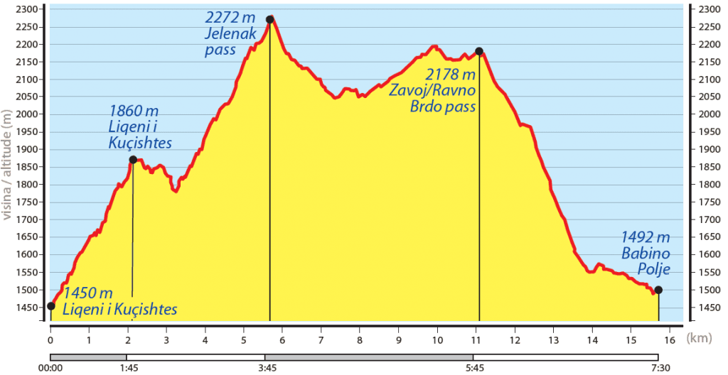
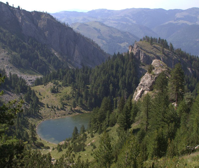
The stage begins with a short car transfer to Kuqishte village, starting near the Guri Kuq Restaurant in the Liqenat area. From here, the trail heads south for approximately 2.2 km, climbing 400 meters through dense conifer forest to the first glacial lake, Liqenat i Kuqishtës (1,890 m) — a serene high-altitude lake that sets the tone for the dramatic scenery ahead.
The route then continues east along the shoreline toward the second glacial lake, Liqenat i Drelajve. Winding through fragrant pine forest and past a natural mountain spring, the trail ascends gently to the lake’s edge — between May and July, the water often glows in a striking turquoise blue, making it one of the most photographed spots on the entire Peaks of the Balkans route.
From the lake, the path climbs through Lugu i Shkodrës and continues for 1.7 km to Jelenka Pass (2,275 m). The pass delivers one of the trail’s finest rewards: unobstructed 360-degree panoramic views across the surrounding Albanian and Montenegrin peaks and valleys — a highlight for any serious alpine hiker.
Beyond Jelenka, the trail traces the Kosovo–Montenegro border ridge before reaching Zavoj Pass (Sedlo Zavoj), where the imposing Mariashi Peak (2,522 m) dominates the skyline to the left. Here the route crosses into Montenegro and begins its descent toward Babino Polje, passing through open alpine meadows, seasonal wildflowers, and blueberry-covered slopes before dropping through forest to traditional shepherd huts and a 4WD track leading into the village.
Babino Polje is a charming traditional Montenegrin shepherd settlement, celebrated for its fresh dairy products and hearty local mountain cuisine. Positioned just 13 km from Plav, the village is easily reachable by car and offers several welcoming guesthouses — making it a perfect overnight stop on the Peaks of the Balkans trail.
Trail Map
Elevation Profile
Download GPX Track
Import this track into your GPS device or hiking app