
YOUR POB TRIP
Peaks of the Balkans Map
This is a map guide of the Western Balkans’ wildest and most unspoiled mountain range, which stretches through Albania, Kosovo, and Montenegro.
To make sure you get on your way easily each day, even when the trail passes through uninhabited mountain regions, we can provide you with detailed Peaks of the Balkans topographic Map and the GPS tracks to use via a smartphone app or on your own GPS device. The map below is Peaks of the Balkans Classic Route, which encompasses 10 hiking days, featuring routes to the most scenic villages and summer huts of the three countries, as well as crossing borders outside of the official border crossing checkpoints.
We do also provide suggestions depending on your preferences and plans. For further information, please contact us, and we will provide you with itineraries designed in cooperation with our guides.
Peaks of the Balkans Map – Trail Map, Route Overview and Download
The Peaks of the Balkans map helps hikers understand one of Europe’s most spectacular long-distance trekking routes. The trail forms a 192-kilometer circular hiking route through Albania, Kosovo, and Montenegro, crossing remote mountain valleys, shepherd paths, and historic villages in the Accursed Mountains (Bjeshkët e Nemuna / Prokletije).
On this page you will find a detailed Peaks of the Balkans trail map, information about the route, and a downloadable PDF map that can help you navigate the trail.
Whether you are planning a self-guided Peaks of the Balkans trek or joining a guided hiking tour, having a reliable map is essential for safe navigation.
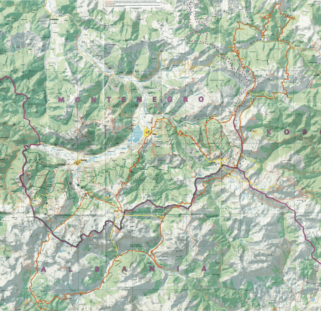
Peaks of the Balkans Trail Map Overview
The Peaks of the Balkans trail is a circular route connecting mountain regions in three countries:
- Albania
- Kosovo
- Montenegro
The route follows traditional shepherd trails and historical cross-border paths used for centuries by local mountain communities.
Trail statistics
| Feature | Details |
|---|---|
| Total distance | 192 km |
| Typical duration | 10 days |
| Minimum elevation | 670 m |
| Maximum elevation | 2,290 m |
| Total ascent | approx. 9,800 m |
| Countries crossed | Albania, Kosovo, Montenegro |
The map shows the main trekking loop, but hikers often adapt stages depending on weather, fitness, and accommodation availability.
Download the Peaks of the Balkans Map (PDF)
You can download a detailed Peaks of the Balkans hiking map below. This map provides a clear overview of the route and helps hikers visualize the main valleys, mountain passes, and villages along the trail.
Download the PDF map:
The map is useful for:
- Understanding the full trail layout
- Identifying daily trekking stages
- Seeing the border crossings between the three countries
- Planning logistics such as guesthouses and transfers
For navigation on the trail, we recommend combining the map with GPS tracks or a hiking navigation app.
Countries and Regions on the Peaks of the Balkans Map
One of the unique aspects of the Peaks of the Balkans trail is that it crosses three countries without using official border crossings. Special permits allow hikers to walk through high mountain passes between Albania, Kosovo, and Montenegro.
Albania
The Albanian part of the trail includes some of the most famous villages in the Accursed Mountains:
- Theth
- Valbona
- Çerem
- Dobërdol
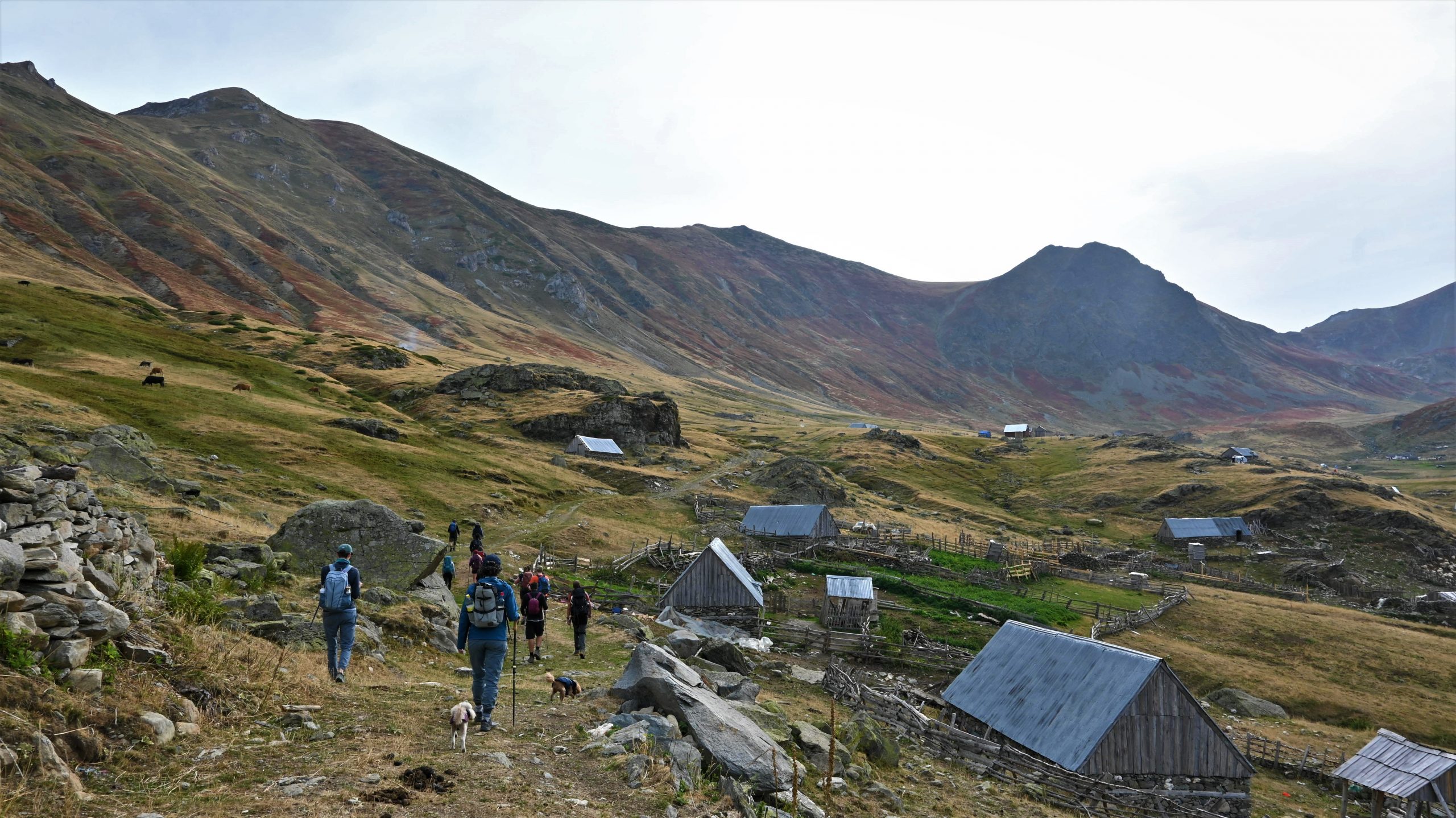
These areas are known for dramatic limestone peaks, alpine meadows, and traditional stone houses.
Kosovo
In Kosovo the trail passes through the Rugova Mountains, including villages such as:
- Milishevc
- Reka e Allagës
- Drelaj
This section offers beautiful forests and views of some of the highest peaks in the region.
Montenegro
The Montenegrin section runs through the Prokletije National Park area, including:
- Vusanje
- Plav
- Babino Polje
These stages include high alpine passes and spectacular views toward peaks like Maja Jezercë.
How to Use the Peaks of the Balkans Map
The map gives a clear overview of the trail, but hikers should also prepare with detailed navigation tools.
Recommended navigation tools include:
- GPS tracks for each stage
- Topographic maps
- Offline hiking apps
- Local guidebooks
Many hikers combine the PDF map with digital navigation on their smartphone.
Peaks of the Balkans Map and Trail Stages
The classic route is typically completed in 10 hiking days, although shorter versions of the trail are possible.
Typical stages include:
- Theth – Valbona
- Valbona – Çerem
- Çerem – Dobërdol
- Dobërdol – Milishevc
- Milishevc – Reka e Allagës
- Reka e Allagës – Drelaj
- Drelaj – Vusanje
- Vusanje – Theth (via Peja Pass)
- Optional extensions and alternative routes
The map helps visualize how these stages connect across the mountain ranges.
Why a Good Map is Important on Peaks of the Balkans
The Accursed Mountains are one of the most remote mountain regions in Europe. While the trail is increasingly popular, navigation can still be challenging.
A good Peaks of the Balkans map helps hikers:
- Understand the terrain
- Plan daily stages
- Identify alternative routes
- Navigate remote sections
- Prepare for elevation changes
For this reason many hikers use both a printed map and GPS navigation during their trek.
Planning Your Peaks of the Balkans Trek
Before hiking the trail, hikers should prepare the following:
- Border crossing permits
- Accommodation reservations
- GPS tracks or navigation tools, found in every trail.
- Proper mountain equipment
- Weather planning
If you prefer assistance with logistics, guided and self-guided trekking services are available.
👉 Learn more about the trail here:
https://peaksofthebalkans.info
Frequently Asked Questions
How long is the Peaks of the Balkans trail?
The full trail is approximately 192 kilometers long and usually takes 10 days to complete.
Do I need a special map for Peaks of the Balkans?
Yes. While the trail is marked in many places, hikers should always carry a map or GPS navigation.
Can I hike Peaks of the Balkans without a guide?
Yes. Many hikers complete the trail self-guided, but proper preparation and navigation tools are essential.
Where can I download the Peaks of the Balkans map?
You can download the PDF map directly from this page and use it together with GPS tracks for navigation.